Novaya Zemlya
Jump to navigationJump to search
| Но́вая Земля́ | |
|---|---|

Map of Novaya Zemlya
|
|

Location of Novaya Zemlya, including the site of the Tsar Bomba detonation
|
|
| Geography | |
| Location | Arctic Ocean |
| Coordinates | 74°N 56°ECoordinates: 74°N 56°E |
| Major islands | 2 |
| Area | 90,650 km2 (35,000 sq mi) |
| Highest elevation | 1,547 m (5075 ft) |
| Administration | |
| Federal subject | Arkhangelsk Oblast |
| Largest settlement | Belushya Guba (pop. 1,972) |
| Demographics | |
| Population | 2,429 (2010) |

Novaya Zemlya (/ˌnoʊvəjə ˈzɛmliə/, also UK: /ˌnɒv-, –aɪ.ə -/, US: /- zɛmˈl(j)ɑː/;[1][2] Russian: Но́вая Земля́, IPA: [ˈnovəjə zʲɪmˈlʲa], lit. ‘”New Land”‘), also known as Nova Zembla (especially in Dutch)[3], is an archipelago in the Arctic Ocean in northern Russia and the extreme northeast of Europe, the easternmost point of Europe lying at Cape Flissingsky on the Northern island. West of Novaya Zemlya is the Barents Sea, and to the east is the Kara Sea.
Novaya Zemlya is composed of two main islands, the northern Severny Island and the southern Yuzhny Island, which are separated by the Matochkin Strait. Administratively, it is incorporated as Novaya Zemlya District, one of the twenty-one in Arkhangelsk Oblast, Russia.[4] Municipally, it is incorporated as Novaya Zemlya Urban Okrug.[5]
The population of Novaya Zemlya, as of the 2010 Census, was about 2,429, of which 1,972 resided in Belushya Guba,[6] an urban settlement that is the administrative center of Novaya Zemlya District. The indigenous population (from 1872[7][8] to the 1950s when it was resettled to the mainland) consisted of about 50–300 Nenetses[9] who subsisted mainly on fishing, trapping, reindeer herding, polar bear hunting and seal hunting.[10][11] Natural resources include copper, lead, and zinc.[10]
Novaya Zemlya was a sensitive military area during the Cold War years, and parts of it are still used for airfields today. The Soviet Air Force maintained a presence at Rogachevo on the southern part of the southern island, on the westernmost peninsula (71.61787°N 52.47884°E). It was used primarily for interceptor aircraft operations, but also provided logistical support for the nearby nuclear test area. Novaya Zemlya was the site of one of the two major nuclear test sites managed by the USSR, used for air drops and underground testing of the largest of Soviet nuclear bombs, in particular the October 30, 1961, air burst explosion of Tsar Bomba, the largest, most powerful nuclear weapon ever detonated.
History[edit]

Willem Barentsz‘ ship among the Arctic ice
The Russians knew of Novaya Zemlya from the 11th century, when hunters from Novgorod visited the area.[12] For Western Europeans, the search for the Northern Sea Route in the 16th century led to its exploration.[12] The first visit from a Western European was by Hugh Willoughby in 1553.[12] Dutch explorer Willem Barentsz reached the west coast of Novaya Zemlya in 1594, and in a subsequent expedition of 1596, he rounded the northern cape and wintered on the northeastern coast.[13] (Barentsz died during the expedition, and may have been buried on Severny Island.[14]) During a later voyage by Fyodor Litke in 1821–1824, the western coast was mapped.[12] Henry Hudson was another explorer who passed through Novaya Zemlya while searching for the Northeast Passage.[15]
The islands were systematically surveyed by Pyotr Pakhtusov and Avgust Tsivolko during the early 1830s. The first permanent settlement was established in 1870 at Malye Karmakuly, which served as capital of Novaya Zemlya until 1924. Later the administrative center was transferred to Belushya Guba,[8][16] in 1935 to Lagernoe,[8] but then returned to Belushya Guba.
Small numbers of Nenets were resettled to Novaya Zemlya in the 1870s in a bid by Russia to keep out the Norwegians. This population, then numbering 298, was transferred to the mainland in 1957 before nuclear testing began.[11][17][18][19]
In 1943, during the Second World War, Novaya Zemlya briefly served as a secret seaplane base for Nazi Germany‘s Kriegsmarine, to provide German surveillance of Allied shipping en route to Siberia. The seaplane base was established by U-255 and U-711, which were operating along the northern coast of Soviet Russia as part of 13th U-boat Flotilla. Seaplane sorties were flown in August and September 1943.[20]
-

1599–1601 map of Novaya Zemlya
-

Map of Novaya Zemlya from 1720.


World War II[edit]
|
|
This section possibly contains original research. (December 2018) (Learn how and when to remove this template message)
|
In the months following Hitler’s June 1941 invasion of the Soviet Union, the United States and Great Britain organized convoys of merchant ships under naval escort to deliver Lend-Lease supplies to northern Soviet seaports. The Allied convoys up to PQ 12 arrived unscathed but German aircraft, ships and U-boats were sent to northern Norway and Finland to oppose the convoys.[21]
Convoy PQ 17[edit]
Convoy PQ 17 consisted of thirty-six merchant ships containing 297 aircraft, 596 tanks, 4,286 other vehicles and more than 150,000 long tons (152,407 t) of other cargo, six destroyer escorts, fifteen additional armed ships (among which were two Free-French corvettes) and three small rescue craft. The convoy departed Iceland on June 27, 1942, one ship running aground and dropping out of the convoy.[22] The convoy was able to sail north of Bear Island but encountered ice floes on June 30; a ship was damaged too badly to carry on and broke radio silence. On the following morning, the convoy was detected by German U-boats and German reconnaissance aircraft and torpedo bomber attacks began on July 2.[23]
On the night of July 2/3, the German battleship Tirpitz and the heavy cruiser Admiral Hipper, sortied from Trondheim with four destroyers and two smaller vessels. Admiral Scheer, Lutzow and six destroyers sailed from Narvik but Lutzow and three destroyers ran aground.[24] The British Admiralty responded on July 4 by diverting the escort vessels to the west to rendezvous with the Home Fleet and ordered the merchant vessels to scatter. Seeking safety in the Matochkin Strait, several ships headed toward Novaya Zemlya. S.A. Kerslake, a crew-member aboard the British trawler Northern Gem, recorded in his diary:[citation needed]
…we were making all haste for Novaya Zemlya, hoping that no German ships had arrived there before us. If they had, and it was thought that escape by sea was impossible, then the three trawlers would be run ashore on one of these God-forsaken islands. We could then salvage what we could from them and try to make our way overland and the sea ice, until we found a settlement, or until we reach the Russian mainland…not a very charming or happy prospect to look forward to.[citation needed]
When the Northern Gem approached Novaya Zemlya and neared the entrance to Matochkin Strait, it quickly reduced speed. Kerslake wrote:
All eyes were hypnotized by the sight of the strait opening up like a page of a picture book. From behind the port side promontory appeared the bows of a ship, and as the angle of our approach opened up the straits more of the vessel came into view. In those first few minutes we thought that the enemy had got there before us, and were waiting to blast us out of the water, but to our intense relief…we saw that it was a corvette…[citation needed]
Another seaman described the strait as “very barren and uninviting, but almost with ‘Welcome’ written along it.”
On July 7 at 4:00 p.m., Captain J. H. Jauncey, the commander of the British anti-aircraft ship Palomares, called a meeting of the commanders of the other ships which had reached the strait. At first, they discussed breaking into the Kara Sea from the east end of the Strait. An officer familiar with the region raised the possibility that the strait, navigable on the west end, might, at the other end, be ice-locked. A seaplane was dispatched which found that the eastern entrance was blocked. Other officers suggested that the ships remain in the strait until “the hue and cry had died down”, adding that “the high cliffs on either side would afford some protection from dive-bombing”.[citation needed]
The ships were painted white and positioned with its armament facing the west entrance. The French corvettes Lotus and La Malouine were dispatched to patrol the entrance to watch for German submarines.[citation needed]
The Breakout[edit]
At 7:00 p.m., the ships re-entered the Barents Sea and headed south. Anticipating the breakout, Rear Admiral Hubert Schmundt had positioned several U-boats near the west end of the strait. Six of the seventeen Allied ships exiting the strait were sunk. The badly-damaged American freighter Alcoa Ranger was beached on the west coast of Novaya Zemlya; the crew found shelter and were eventually rescued by a Russian vessel which took them to Belushya Bay. The Germans also damaged the Soviet tankers Donbass and Azerbaijan which reached the sanctuary of Archangel.[citation needed] Of the thirty-four merchant ships in PQ 17, twenty-four were sunk. The American contingent alone lost more than three-fourths of the merchant ships committed to the convoy — more than one fourth of the losses to American shipping in all convoys to northern Russia.[citation needed]
The PQ 17 delivered 896 vehicles and 3,350 were lost, 164 tanks arrived and 430 did not, 87 aircraft reached the USSR and 210 were lost; 57,176 long tons (58,093 t) of cargo were delivered and 99,316 long tons (100,910 t) was sunk at a cost to the Germans of five aircraft.[25] Karlo Štajner, a Gulag prisoner in Norilsk in 1942, wrote “the German cruiser’s attack on Novaya Zemlya and the sinking of the food transports had catastrophic consequences… the population was left without provisions… supplies in the warehouses of Norilsk [were] distributed among the NKVD, the guards, and the few free civilians that lived in the town”. Štajner and his fellow prisoners received nothing.[citation needed] Between July and August 1942, German U-boats destroyed the Maliyye Karmakuly polar station and damaged the station at Mys Zhelaniya. German warships also destroyed two Soviet seaplanes and staged an attack on ships in Belushya Bay.[citation needed]
Operation Wunderland[edit]
In August 1942, the German Navy commenced Operation Wunderland, to enter the Kara Sea and sink as many Soviet ships as possible. Admiral Scheer and other warships rounded Cape Desire, entered the Kara Sea and attacked a shore station on Dikson Island, badly damaging the Soviet ships Dezhnev and Revolutionist.[citation needed] Later that year, Karlo Štajner made the acquaintance of a new prisoner, a Captain Menshikov, who told him that:
“In August 1942, another…transport arrived in Novaya Zemlya. The escort ships turned around and went back. Just a few hours later, the watchman in the tower announced that a ship was in sight. Everyone assumed it was one of the Allied warships and didn’t give the matter any importance. Shortly after, the watchman announced that the ship was nearing the bay. I went outside…to see for myself. As soon as I had climbed the tower, I realized to my horror that this was a German warship. I gave the alarm, but it was too late… the German cruiser was coming closer. One of the Allied freighters — the first ship we managed to get moving — steered its way out of the bay. That’s all the Germans were waiting for. At the moment when the ship reached the narrowest part of the bay, the German guns sent off their first salvo — a direct hit… our coastal batteries opened fire… but the guns didn’t reach far enough… [they] came closer and destroyed all the ships in the bay, as well as a large part of the harbor [and] left a hundred dead and wounded.”
Whether the attack on Menshikov’s battery occurred on Dikson Island or on Novaya Zemlya, Stajner’s account illuminated the fate of a Soviet officer imprisoned by his countrymen for the “crime” of suffering defeat at the hands of the enemy. Not surprisingly, Menshikov’s arrest was never announced in the Soviet press. In August 1943, a German U-boat sank the Soviet research ship Akademic Shokalskiy near Mys Sporyy Navolok but the Soviet Navy, now on the offensive, destroyed the German submarine U-639 near Mys Zhelaniya.
Nuclear testing[edit]
| Novaya Zemlya Test Site | |
|---|---|

Novaya Zemlya Test Site boundaries and facilities
|
|
| Type | Nuclear test site |
| Area | land: 55,200 km2 (21,300 sq mi) water: 36,000 km2 (14,000 sq mi) |
| Site information | |
| Operator | Russian Federation (formerly Soviet Union) |
| Status | Active |
| Site history | |
| In use | 1955–present |
| Test information | |
| Subcritical tests | not known |
| Nuclear tests | 224 |
In July 1954, Novaya Zemlya was designated the Novaya Zemlya Test Site, construction of which began in October[26] and existed during much of the Cold War. “Zone A”, Chyornaya Guba (70.7°N 54.6°E), was used in 1955–1962 and 1972–1975.[26] “Zone B”, Matochkin Shar (73.4°N 54.9°E), was used for underground tests in 1964–1990.[26] “Zone C”, Sukhoy Nos (73.7°N 54.0°E), was used in 1958–1961 and was the site of the 1961 test of the Tsar Bomba, the most powerful nuclear weapon ever detonated.[26]
Other tests occurred elsewhere throughout the islands, with an official testing range covering over half of the landmass. In September 1961, two propelled thermonuclear warheads were launched from Vorkuta Sovetsky and Salekhard to target areas on Novaya Zemlya. The launch rocket was subsequently deployed to Cuba.[27]
1963 saw the implementation of the Limited Test Ban Treaty which banned most atmospheric nuclear tests.[28] The largest underground test in Novaya Zemlya took place on September 12, 1973, involving four nuclear devices of 4.2 megatons total yield. Although far smaller in blast power than the Tsar Bomba and other atmospheric tests, the confinement of the blasts underground led to pressures rivaling natural earthquakes. In the case of the September 12, 1973 test, a seismic magnitude of 6.97 on the Richter Scale was reached, setting off an 80 million ton avalanche that blocked two glacial streams and created a lake 2 kilometres (1.2 mi) in length.[28]
Over its history as a nuclear test site, Novaya Zemlya hosted 224 nuclear detonations with a total explosive energy equivalent to 265 megatons of TNT.[26] For comparison, all explosives used in World War II, including the detonations of two US nuclear bombs, amounted to only two megatons.[28]
In 1988–1989, glasnost helped make the Novaya Zemlya testing activities public knowledge,[26] and in 1990 Greenpeace activists staged a protest at the site.[29] The last nuclear test explosion was in 1990 (also the last for the entire Soviet Union and Russia). The Ministry for Atomic Energy has performed a series of subcritical underwater nuclear experiments near Matochkin Shar each autumn since 1998.[30] These tests reportedly involve up to 100 grams (3.5 oz) of weapons-grade plutonium.[31]
In October 2012, it was reported that Russia would resume subcritical nuclear testing at “Zone B”. In Spring 2013, construction of what would become a new tunnel and four buildings[32] was initiated near the Severny settlement, 3 km west-northwest to the Mount Lazarev.[33][34]
Geography[edit]

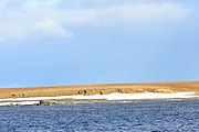
Landscape in Novaya Zemlya, Russian Arctic National Park
Novaya Zemlya is an extension of the northern part of the Ural Mountains,[35] and the interior is mountainous throughout.[12] It is separated from the mainland by the Kara Strait.[12] Novaya Zemlya consists of two major islands, separated by the narrow Matochkin Strait, as well as a number of smaller islands. The two main islands are:
- Severny (Northern), which has a large ice cap, the Severny Island ice cap, as well as many active glaciers.
- Yuzhny (Southern), which is largely unglaciated and has a tundra landscape.[10]
The coast of Novaya Zemlya is very indented, and it is the area with the largest number of fjords in the Russian Federation. Novaya Zemlya separates the Barents Sea from the Kara Sea. The total area is about 90,650 square kilometers (35,000 sq mi). The highest mountain is located on the Northern island and is 1,547 meters (5,075 ft) high.[36]

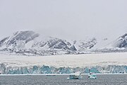
Wide shot of Novaya Zemlya
Compared to other regions that were under large ice sheets during the last glacial period, Novaya Zemlya shows relatively little isostatic rebound. Possibly this is indebted to a counter-effect created by the growth of glaciers during the last few thousand years.[37]
-
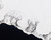
Natural-color satellite image of the Nordenskiöld Glacier group. East coast, Severny
-
Barents Bay (Willem Barents’ gravesite; 76°27’N, 68°42’E)
-
Inostrantsev Glacier terminus (76°28‘N, 66°5‘E)
-

Cape Zhelaniya (Northernmost cape of Severny; 76°57’N, 68°35’E)


Environment[edit]
The ecology of Novaya Zemlya is influenced by its severe climate, but the region nevertheless supports a diversity of biota. One of the most notable species present is the polar bear, whose population in the Barents Sea region is genetically distinct from other polar bear subpopulations.[38]
Climate[edit]
| hideClimate data for Malye Karmakuly, Novaya Zemlya | |||||||||||||
|---|---|---|---|---|---|---|---|---|---|---|---|---|---|
| Month | Jan | Feb | Mar | Apr | May | Jun | Jul | Aug | Sep | Oct | Nov | Dec | Year |
| Record high °C (°F) | 2.6 (36.7) |
1.7 (35.1) |
2.0 (35.6) |
7.8 (46.0) |
17.6 (63.7) |
22.2 (72.0) |
28.3 (82.9) |
23.8 (74.8) |
16.5 (61.7) |
9.7 (49.5) |
4.5 (40.1) |
2.5 (36.5) |
28.3 (82.9) |
| Average high °C (°F) | −10.9 (12.4) |
−11.5 (11.3) |
−9.1 (15.6) |
−6.7 (19.9) |
−1.4 (29.5) |
4.9 (40.8) |
10.3 (50.5) |
9.0 (48.2) |
5.5 (41.9) |
−0.1 (31.8) |
−4.8 (23.4) |
−8.1 (17.4) |
−1.9 (28.6) |
| Daily mean °C (°F) | −14.1 (6.6) |
−14.7 (5.5) |
−12.2 (10.0) |
−9.9 (14.2) |
−3.7 (25.3) |
2.5 (36.5) |
7.3 (45.1) |
6.8 (44.2) |
3.7 (38.7) |
−1.8 (28.8) |
−7.1 (19.2) |
−11.1 (12.0) |
−4.5 (23.9) |
| Average low °C (°F) | −17.3 (0.9) |
−17.9 (−0.2) |
−15.2 (4.6) |
−13.0 (8.6) |
−5.8 (21.6) |
0.7 (33.3) |
5.1 (41.2) |
4.9 (40.8) |
2.1 (35.8) |
−4.0 (24.8) |
−9.9 (14.2) |
−14.1 (6.6) |
−7.0 (19.4) |
| Record low °C (°F) | −36.0 (−32.8) |
−37.4 (−35.3) |
−40.0 (−40.0) |
−29.9 (−21.8) |
−25.9 (−14.6) |
−9.6 (14.7) |
−2.8 (27.0) |
−1.7 (28.9) |
−9.9 (14.2) |
−21.1 (−6.0) |
−29.1 (−20.4) |
−36.2 (−33.2) |
−40.0 (−40.0) |
| Average precipitation mm (inches) | 30 (1.2) |
26 (1.0) |
24 (0.9) |
20 (0.8) |
15 (0.6) |
23 (0.9) |
36 (1.4) |
31 (1.2) |
39 (1.5) |
35 (1.4) |
24 (0.9) |
33 (1.3) |
336 (13.2) |
| Average rainy days | 1 | 1 | 1 | 1 | 3 | 10 | 15 | 17 | 19 | 9 | 3 | 2 | 82 |
| Average snowy days | 18 | 18 | 19 | 17 | 17 | 10 | 1 | 1 | 6 | 17 | 19 | 20 | 163 |
| Average relative humidity (%) | 78 | 77 | 77 | 76 | 78 | 81 | 83 | 83 | 85 | 82 | 79 | 78 | 80 |
| Mean monthly sunshine hours | 0 | 25 | 107 | 215 | 189 | 173 | 229 | 143 | 73 | 40 | 3 | 0 | 1,197 |
| Source 1: Pogoda.ru.net[39] | |||||||||||||
| Source 2: NOAA (sun 1961–1990)[40] | |||||||||||||
Polar bears enter human-inhabited areas more frequently than previously, which has been attributed to climate change. Global warming reduces sea ice, forcing the bears to come inland to find food. In February 2019, a mass migration occurred in the northeastern portion of Novaya Zemlya. Dozens of polar bears were seen entering homes, public buildings, and inhabited areas, so Arkhangelsk region authorities declared a state of emergency on Saturday, February 16, 2019.[41][42]